Oregon Breeding Bird Atlas
Hexagons window
 This hexagons window gives access to detail maps of the hexagons. It also
has statewide summaries of some results of the atlas
in both map and table form. Summaries are given for the hexagons
and, where the data is available, for the squares as well.
This hexagons window gives access to detail maps of the hexagons. It also
has statewide summaries of some results of the atlas
in both map and table form. Summaries are given for the hexagons
and, where the data is available, for the squares as well.
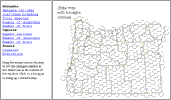
 As you move the mouse across the map, you may see the hexagon number
in the status bar at the bottom of the window. Click on a hexagon
to bring up a detailed map.
As you move the mouse across the map, you may see the hexagon number
in the status bar at the bottom of the window. Click on a hexagon
to bring up a detailed map.
 You may find the actual figures for each hexagon or square through
the statistics link. Also, the detailed map of a hexagon gives a further
breakdown of the observational summary. The counties link shows a map
of the counties, with county names.
You may find the actual figures for each hexagon or square through
the statistics link. Also, the detailed map of a hexagon gives a further
breakdown of the observational summary. The counties link shows a map
of the counties, with county names.
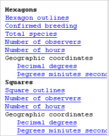 The Confirmed species map shows the number of species for which the
observations were of confirmed breeding evidence. The Total species
shows the number of species for which the observations were of some
breeding evidence, though breeding may not have been confirmed. The number
of observers is a count of the number of people who turned in observations
for the hexagon. The number of hours is a total of the time spent
by all observers in the hexagon. The Geographic coordinates links give
tables of the coordinates of each hexagon, one table in decimal degrees,
the other in degrees minutes seconds.
The Confirmed species map shows the number of species for which the
observations were of confirmed breeding evidence. The Total species
shows the number of species for which the observations were of some
breeding evidence, though breeding may not have been confirmed. The number
of observers is a count of the number of people who turned in observations
for the hexagon. The number of hours is a total of the time spent
by all observers in the hexagon. The Geographic coordinates links give
tables of the coordinates of each hexagon, one table in decimal degrees,
the other in degrees minutes seconds.
The Squares outline shows the location of the squares on a statewide
map. The number
of observers is a count of the number of people who turned in observations
for the square. The number of hours is a total of the time spent
by all observers in the square. The Geographic coordinates links give
tables of the coordinates of each square, one table in decimal degrees,
the other in degrees minutes seconds.